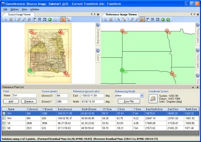
Geographic Transformer contains the most powerful raster transformation tools available today allowing for higher order math transformation models, up to fifth order polynomial, for true warping and accurate reprojection. The Transformer also sits on GeoCalc.XML, the world's largest, most reliable and accurate coordinate transformation datasource. The tool also has great batching capabilities for large transformation jobs. Transformer allows users to georeference images, reproject them, as well as tile and mosaick the data. The application allows you to reference an image from either an existing reference file, or by using our popular and user friendly “point-and-click” method with an already referenced image. The tool essentially sets up a relationship between known control points and the associated pixels values of your image. The Transformer also has great file format support and cutting edge compression capabilities. Transformer supports all the major GIS file formats including read and write of the three major compression formats ECW, JPG2000, and MrSID, as well as Digital Elevation Model and DTED Military Elevation support. You can save your work out in whatever file format you need as one image, a mosaic of images or smaller tiled pieces.


Comments (1)